COURTOWN WOODLAND
RIVER WALK
Distance: 1.9km (1.2 miles)
Ascent: 27m
Walking time : 40min
Waymarking: Red
Grade: Easy
CANAL WALK
Distance : 1km (0.6 miles)
Ascent : –
Walking time: 25 min
Waymarking: Green
Grade: Easy
TOP WALK
Distance: 1.2km (0.75 miles)
Ascent: –
Walking time: 35min
Waymarking: Blue
Grade: Easy
HIGH CROSS
Distance: 1km (0.6 miles)
Ascent: –
Walking time: 30min
Waymarking: Brown
Grade: Easy
OSI Discovery Map Series 69
GRID REFERENCE: T1995456599
SAT NAV: 52.644, -6.228
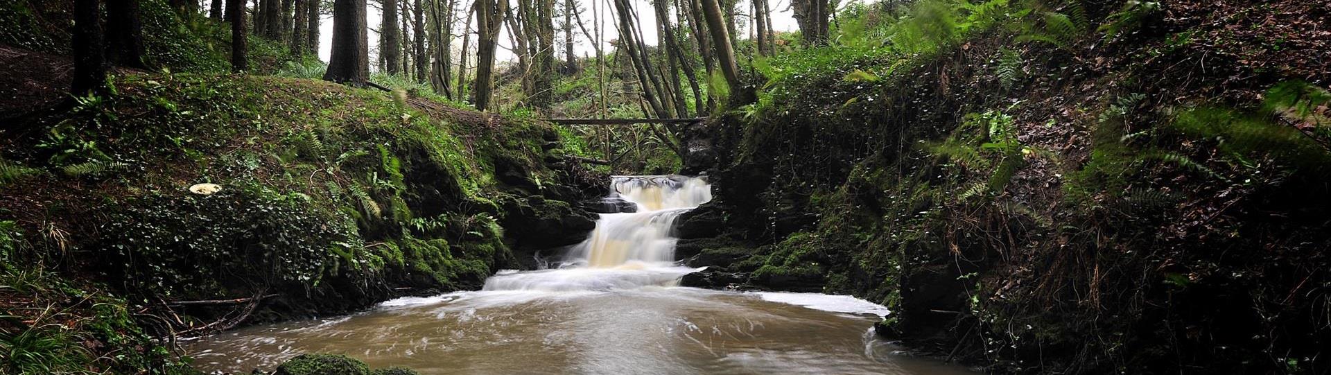
Bounded by the Owenavorragh River on the north side and the canal on the seaward side to the east, Courtown Woodland dates back to pre-Famine times. At 25 hectares, it was once home to oak and ash trees. Acquired by the State in the late 1950s, it was planted with commercial timber. The mixed conifers – broadleaf plantings – were largely of spruce with some ash although small strands of oak remain together with avenues of chestnut and lime trees. The canal was constructed under a Famine relief scheme in 1847 and, as you choose your walk along the River Walk, Top Walk, Canal Walk or High Cross Walk, you are following in the footsteps of the previous Lords and Ladies of Courtown and their visitors. Keep an eye out for remaining trees from the fifth Earl’s conifer collection, including Californian redwood, swamp cypress, Japanese cedar, cedar of Lebanon and a number of pine, yew and true cypresses. You will also notice common oak, ash, sycamore whilst, unfortunately, English Elm dating from the 1840s have mostly succumbed to Dutch Elm disease and are now suckering remnants of once fine, pre-Famine trees. A beautiful woodland area offering a cool green respite from the sunshine and sea in Courtown, these walks, with a tree-lined avenue, offer a glimpse of the past and a chance to recover from today’s busy schedules while smelling the wild garlic!
DON’T MISS
- The 2.5m high High Cross of Kilbride, the sole reminder of an early Christian church in the area.
- Ballinatray Bridge, once amongst the tallest viaducts in Ireland.
- A majestic cedar of Lebanon on the river bank viewed from the Top Walk
- A yew tree planted in the 1870s, felled many years ago, continues to grow adjacent to the River Walk.
- Late spring’s spectacular white carpet of wild garlic blossom covering the woodland floor, followed by a delicate show of bluebells.
- Courtown Adventure and Leisure Centre – Family-orientated centre with something for every age group: climbing wall, aerial trekking, zip wire, abseiling, quick jump, archery, laser tag, junior gravity, junior playground, 3 pools, 2 slides and gym.
- Seal Rescue Ireland, located on the grounds of Courtown Leisure Centre.
For further details, log into www.courtownadventure.ie
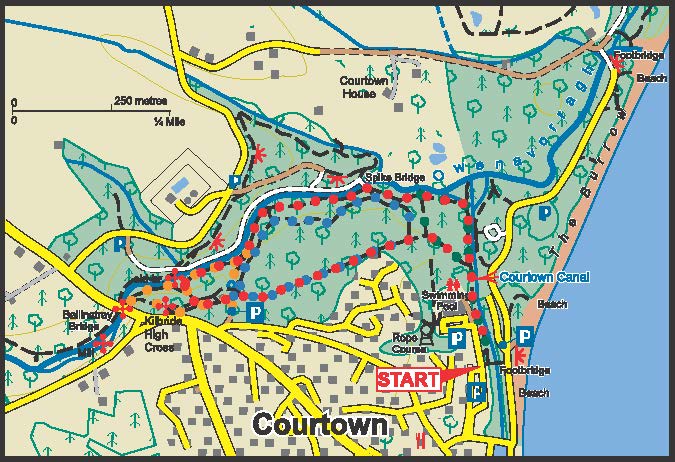
GETTING HERE
Directions: From Gorey, take Courtown Road R742, on the approach to the village, take left turn at the V and Woodlands carpark and Trailhead 1 is on the left From Gorey, take Courtown Road R742, on the approach to the village, take left turn at the V and follow signs for Courtown Adventure and Leisure Centre. Trailhead 2 is beside main entrance to the Centre From M11: Take exit 23 and Road R742 towards Courtown and follow signs for Courtown Adventure and Leisure Centre