Clody Valley – Craan Loop
Grade: Moderate
Distance: 15 km / 9.5 miles
Waymarking: Pink
Trailhead: Bunclody town
Sat Nav:
Parking: Free parking is available in the town centre

Trail Description
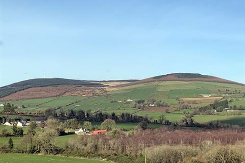
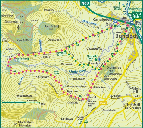
This is a scenic peaceful looped walk around the Clody Valley, sided by the Blackstairs Mountains with Mount Leinster itself as the focal mid-point on the loop. The loop meanders beside farmland, forestry, streams and open mountain. From Droim Cria (the slate quarry), Blackrock Mountain, Mount Leinster, Kilbranish Windmills, New Deerpark, John’s Hill, Clonmullen and Barkers Road you get many different views of the whole Clody Valley with the Blackstairs Mountains to the west, the Wicklow foothills to the north and the Wexford coastline to the east as you return.
The slate quarry at Droim Cria on your left where slate was quarried for over 100 years to roof houses, both local and far afield – you will spot some houses and sheds roofed with local slate along the route. Turning right, Blackrock Mountain is to your left, while every gateway on the right opens to spectacular valley views towards the wind turbines, Deerpark and Johns Hill. As you walk from County Wexford towards County Carlow, Mount Leinster comes into view on your left. At the summit of Mount Leinster, Labraid Loingsech is said to have been buried. He was one of the first Kings of Leinster (3rd century BC). Legend says he gave the name Laigin (Gaelic for Leinster) to the province from the Spears of the soldiers he brought from France to regain his Kingdom. Saint Columbanus an important 6th century Irish saint was born near the Nine Stones.
There is a large herd of deer in the Clody Valley, originally all were in the northern slopes of the Deerpark, but recently they have flourished in the Coilte forest of New Deerpark. There are incredible sunrises and sunsets to be enjoyed. You will need your camera out for the entire walk as there is plenty of beautiful landscape to photograph.
Don’t Miss…
- The old-fashioned water pump at Ballyprecas
- Droim Cria where slate was quarried for over 100 years
- Mount Leinster (on your left). The highest peak of the Blackstairs Mountains
- As you head back towards Bunclody town the surrounding area opens in front of you. From the top you can see right out to the Wexford coastline, here too you can see all the way from Tara Hill near Gorey to the Wicklow Mountains and Lugnaquillla.
- The Clody River – Clody meaning a stony, fast flowing river
- Stop to enjoy an ice cream sitting under the trees on The Mall
Useful Trail Information
OSI Discovery Map Series: 68
Grid Reference:
Ascent: Rising to 180m
(with some long steep climbs)
Walking time: 3.5 to 4 hours
Format: Loop
Surface: Public road
Gates/Stiles: No
Start/Finish: Bunclody town centre
Equipment Recommended: Specific outdoor walking footwear and clothing is recommended for a moderate grade trail.
Other Useful Information
Mobile Coverage:
Picnic Area:
Public Toilets:
Dogs: Dogs must be kept under control at all times.
You must clean up after your dog if it fouls in a public place.
Public Transport:

Other Walking Trails Nearby
Clody Valley – Long Lane Loop
Coolmelagh
Askamore

Getting Here
Bunclody is on the N80 just 21km from Enniscorthy and 30km from Gorey.

Trail Grades
Trail grades give an indication of what to expect when out on a trail. The grade will give an idea of the level of fitness and ability required to use the trail.
Before attempting a trail, it is important to consider the grading to ensure it matches your ability and level of fitness.
Wexford Walking Trails are graded by Sport Ireland according to their criteria which is explained here.
Multi-Access
Flat smooth trails, suitable for all users including people with reduced mobility, wheelchair users, people with a vision impairment, using crutches, with a buggy, with small children, older people and so on. Normal outdoor footwear can be worn. Source : Sport Ireland
Moderate
These trails may have some climbs and may have an uneven surface where the going is rough underfoot with some obstacles such as protruding roots, rocks, etc. The routes are appropriate for people with a moderate level of fitness and some walking experience. Specific outdoor walking footwear and clothing is recommended. Source : Sport Ireland
Easy
Generally flat trails with a smooth surface and some gentle slopes or shallow steps. These trails are generally suitable for family groups including children and older people. Normal outdoor footwear can be worn. Source : Sport Ireland
Strenuous
These are physically demanding trails, which will typically have some sections with steep climbs for long periods and the going underfoot can be extremely rough including many obstacles. Suitable for users accustomed to walking on rough ground and with a high level of fitness. Specific outdoor walking footwear and clothing required. Source : Sport Ireland
